
By: Pat Clark | 04/20/2022 Rangeland Scientist, USDA-ARS Northwest Watershed Research Center, Boise, Idaho
Dr. Clark is developing and evaluating UAS imagery collection and analysis workflows with an eye towards augmenting or replacing field biomass measurements on spatially-extensive rangelands.
Working in several shrub-steppe vegetation types of the Great Basin region, Dr. Clark is using imagery collected using unmanned aerial systems (UAS) to develop digital surface, digital terrain, and canopy height models to intensively measure vegetation height, volume, and density. Plant seasonal production, fuel load, and biomass are then estimated from these vegetation structural measurements. Python scripts, originally developed by Andrew Cunliffe and colleagues at Exeter University (UK), are being used by Dr. Clark to automate imagery processing using software on the Atlas HPC. While a large portion of this analysis workflow can be accomplished with batch scripts, some steps require dynamic interaction with the analyst. Dr. Clark is using the Open OnDemand system available on Atlas to accomplish these interactive tasks.
Preliminary results are promising, but a considerable amount of evaluation and validation remain to be conducted. Expected products from this research include automated workflows, coded as python scripts, for conducting Structure from Motion (SfM), orthorectification, and mosaicking analyses. Additional workflow and model products will then enable a user to estimate production, fuel load, and biomass for rangeland plant functional types based on SfM-derived vegetation structure. This research holds promise for providing natural resource managers, fire and fuels specialists, and livestock producers with an efficient method to estimate rangeland biomass parameters using affordable, off-shelf UAS platforms and validated processing and analysis workflows.
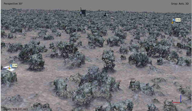
Image 1. The image illustrates the use of the Atlas Open OnDemand web interface to conduct the interactive workflow step of inspecting a dense point cloud created using Structure from Motion (SfM) analysis of UAS imagery. This dense point cloud represents a Wyoming big sagebrush plant community located at the Reynolds Creek Experimental Watershed in southwestern Idaho (Great Basin LTAR site). Shrubs illustrated here are about 0.25 to 0.5 m tall. Note the ground control point (GCP) target in the foreground and eddy covariance/phenocam tower in the background.