
By: Craig D. Woodruff | 01/25/2024 Computational Biologist, NWRC, Boise, Idaho
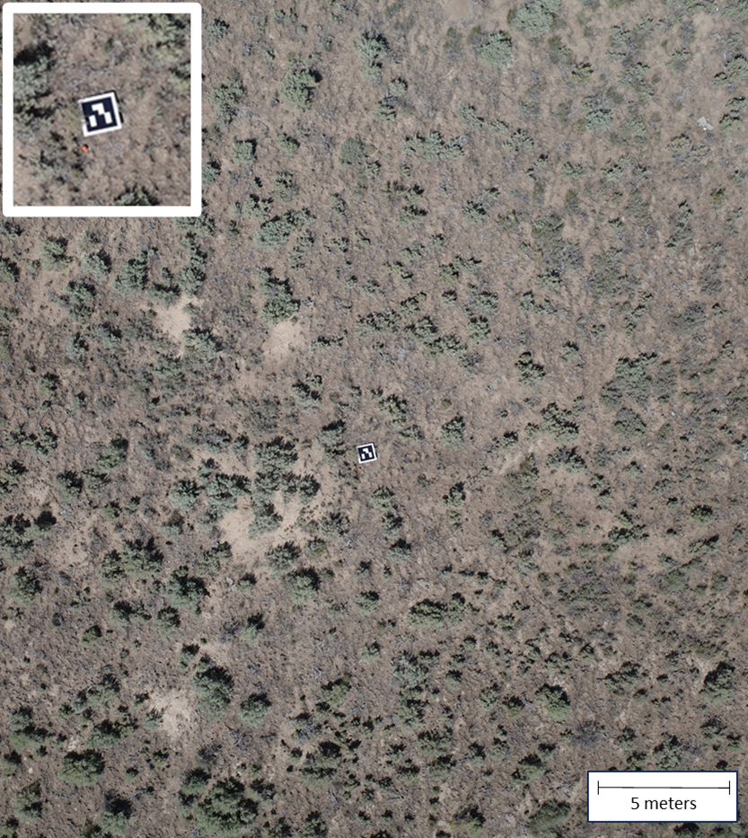 Figure 1: A coded target for automatic ground control point identification is shown in a Wyoming Big Sagebrush-dominated study site in the Reynolds Creek Experimental Watershed. A zoomed-in nested image of the coded target is shown in the upper left corner.
In this Research Spotlight, I would like to highlight the use of SCINet resources for the Unoccupied Aerial Systems (UAS) research program at the ARS Northwest Watershed Research Center (NWRC) in Boise, Idaho. Scientists at the NWRC use UAS to research long-term vegetation dynamics in sagebrush-dominated rangelands. Multispectral, hyperspectral, and natural color imagery are collected to study the effects of fire, grazing, and invasive weed encroachment. A large amount of UAS data has been collected since 2017, and a streamlined processing workflow that is reproducible on the SCINet high-performance computing (HPC) clusters, Atlas and Ceres, is necessary to consistently process these data. HPC image processing tutorials, supporting code, and reference materials are all available on SCINet’s Geospatial Workbook website. These resources have greatly increased the accessibility of the HPC clusters for new and experienced individuals needing to process UAS data. The tutorials not only provide the overview of the necessary steps with examples, code snippets, and animations but they also provide a wealth of knowledge on HPC programming. In the past couple years, the preferred, OCIO-approved UAS processing software has changed to the open-source OpenDroneMap (ODM), and these tutorials have paved the way for implementing this software on SCINet resources.
Processing UAS-collected data can be tricky, and it requires a human component. When we collect the data, we lay out targets referred to as ground control points (GCPs) which help to increase the accuracy of the “stitched together” final products. The area of interest may have a large elevational gradient making the GCPs all the more important to derive accurate orthomosaics, digital surface models, and digital elevation models. Before we process the imagery, someone is required to geotag the GCPs in the images with their respective global positioning system (GPS) coordinate values. This step virtually anchors the images to the ground surface and allows the ODM software to combine the hundreds of images into a single product. Once this is done, any SCINet user can implement the tutorial on processing imagery on Atlas. But the big time sink and potential source of human error is the GCP tagging step, and if it were automated, the processing pipeline would be completely reproducible. One of the newest advances in UAS data collection is coded targets that allow the GCP geotagging step to be automated.
Coded targets, as seen in Figure 1, are printed QR code-style GCPs. When setting these targets out before collecting UAS data, you simply need to record which coded target is at which GCP location. This information is then fed into the processing pipeline, and the GCPs are automatically detected. Aleksandra Badaczewska-Dawid, with the SCINet Virtual Research Support Core (VRSC), and Pat Clark, a Range Scientist at the NWRC, have worked together to develop the tutorial, code, and real-world examples of implementing coded target detection on SCINet’s HPC clusters. This suite of supporting documentation on coded targets fills the final gap in the processing workflow by automating the manual, time-intensive portion of image processing.